 |
| Salt Lake City map, Published by W.H. Whitney, August 1st 1889 |
Maps are fun! This map from 1899 is new to me. It is a real estate map of SLC showing the various platted neighborhoods.
Some examples:
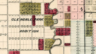
Image 2: Glendale Park Addition
Image 3: Fort Douglas and Red Butte Creek. Poperton Place is the prominent Pink cutout north of Fort Douglas.
Image 4: Utah Driving Park Race Track (500 E 2100 South)
Image 5: Hot Springs Lake (neighborhood to the west in red is near Northwest Middle School)
The official description is "Compiled from the Records and Actual Surveys By Simon F. Mackie, Civil Engineer. Published by W.H. Whitney, August 1st 1889"
There are plenty of sites on the internet that would love to sell you this lovely map, but don't fall for that.
You can download your own copy from Stanford University's Barry Lawrence Ruderman Map Collection.
URL: purl.stanford.edu/sy439kf2563


No comments:
Post a Comment